Some locals like to celebrate the arrival of a New Year by swimming in the sea at Calgary Bay, while others prefer to simply sleep off the excesses of another Hogmanay spent ‘swimming’ in alcohol. Not being brave enough(foolhardy?)to even contemplate dipping our toes in the Atlantic Ocean at this time of the year, and retaining a clear head after the night before, we thought to start 2011 in a way we mean to continue. So, with the weather set fair, forecasting little or no wind and promising far reaching views to die for, we donned our walking boots for the first time this year and headed up the path that leads to the top of Mull’s Matterhorn, Ben More (3,169 ft).

We weren’t the only ones with this in mind, however, as the route proved well-trodden with hillwalkers keen to get their New Year off to the best possible start. Ben More, ‘The Big Hill’, may not be the highest of the 284 Munros in Scotland, yet it does have some rather special qualities. Outside of the Skye Cuillins, it is the only peak that stands over 3,000 feet in the Hebrides and the only mountain in Britain composed of tertiary basalt from head to toe. Additionally, the geology throws up strange magnetic anomalies, which means that you cannot rely on your compass getting you down off the mountain should the cloud base obscure your view!

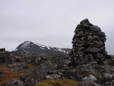
Ben More is a popular resort for hillwalkers all-year-round, yet its shoulder mountain, An Gearna, is rarely visited. In keeping with the Mull Magic pledge to try to celebrate the uncelebrated in 2011, we decided to deviate from the path up the side of the Dhiseig burn, in order to work our way to the cairn at the pinnacle of this ‘lesser’ mountain. We had the hill all to ourselves and enjoyed a truly wonderful few hours admiring the inaccessible (at least to walkers!) North face of Mull’s loftiest location, a view that would have been denied if we had chosen to scale the scree slopes of Ben More.
Although the sun refused to come out from behind the day’s veil of grey, the panorama North and West across Loch na Keal was quite brilliant. Stretching out as far as the eye could see beyond the dark, brooding cliffs of Gribun (1,800 ft) and the Isle of Ulva, we marvelled at the myriad of islands that presented themselves. The island of Staffa lay adrift of the Treshnish archipelago, with the outermost of the Inner Hebrides, Coll and Tiree, tucked behind, while on the grey horizon, sprinkled with the occasional rain shower, the Long Island spread out from Barra to North Uist. From our vantage point on the top of the world, it seemed that we really were looking out towards the very edge of creation!

Our eye’s journey North was equally impressive and dominated by the flat-topped Speinne Mor (1,456 ft), the V-shaped clefts of the Rum Cuillin and the snow-covered peaks of Skye in the distance. The foreground scene of Loch na Keal was governed by the sheep island of Eorsa, the setting for Nigel Tranter’s 1952 comic novel, ‘The Bridal Path’, which was later made into a film starring Bill Travers. In it, Travers plays a character on the look-out for a wife, a journey that, inevitably, takes him away from his island home. Equally inevitably, having failed in his search of the mainland, he finds love on his doorstep when he returns home.

Eorsa, uninhabited save for a local landowner’s sheep, was chosen for this very fact, as the story of book and film was about the dangers of in-breeding within a small community. The author wisely chose an unpopulated location in order not to offend, as well it may have done!
 We weren’t the only ones with this in mind, however, as the route proved well-trodden with hillwalkers keen to get their New Year off to the best possible start. Ben More, ‘The Big Hill’, may not be the highest of the 284 Munros in Scotland, yet it does have some rather special qualities. Outside of the Skye Cuillins, it is the only peak that stands over 3,000 feet in the Hebrides and the only mountain in Britain composed of tertiary basalt from head to toe. Additionally, the geology throws up strange magnetic anomalies, which means that you cannot rely on your compass getting you down off the mountain should the cloud base obscure your view!
 Ben More is a popular resort for hillwalkers all-year-round, yet its shoulder mountain, An Gearna, is rarely visited. In keeping with the Mull Magic pledge to try to celebrate the uncelebrated in 2011, we decided to deviate from the path up the side of the Dhiseig burn, in order to work our way to the cairn at the pinnacle of this ‘lesser’ mountain. We had the hill all to ourselves and enjoyed a truly wonderful few hours admiring the inaccessible (at least to walkers!) North face of Mull’s loftiest location, a view that would have been denied if we had chosen to scale the scree slopes of Ben More.
 Although the sun refused to come out from behind the day’s veil of grey, the panorama North and West across Loch na Keal was quite brilliant. Stretching out as far as the eye could see beyond the dark, brooding cliffs of Gribun (1,800 ft) and the Isle of Ulva, we marvelled at the myriad of islands that presented themselves. The island of Staffa lay adrift of the Treshnish archipelago, with the outermost of the Inner Hebrides, Coll and Tiree, tucked behind, while on the grey horizon, sprinkled with the occasional rain shower, the Long Island spread out from Barra to North Uist. From our vantage point on the top of the world, it seemed that we really were looking out towards the very edge of creation!
 Our eye’s journey North was equally impressive and dominated by the flat-topped Speinne Mor (1,456 ft), the V-shaped clefts of the Rum Cuillin and the snow-covered peaks of Skye in the distance. The foreground scene of Loch na Keal was governed by the sheep island of Eorsa, the setting for Nigel Tranter’s 1952 comic novel, ‘The Bridal Path’, which was later made into a film starring Bill Travers. In it, Travers plays a character on the look-out for a wife, a journey that, inevitably, takes him away from his island home. Equally inevitably, having failed in his search of the mainland, he finds love on his doorstep when he returns home.
 Eorsa, uninhabited save for a local landowner’s sheep, was chosen for this very fact, as the story of book and film was about the dangers of in-breeding within a small community. The author wisely chose an unpopulated location in order not to offend, as well it may have done!


No comments:
Post a Comment