Monday 31 January 2011

If You Go Down To The Woods Today…

With the prospect of an imminently approaching band of inclement weather, we thought to try and make the best of the quietness of last week while we could. With outside temperatures barely rising above freezing point, it was going to be a walk that was laden with binoculars and camera, woolly hat and gloves, as well as the obligatory several layers to ward off the cold. We were headed for a small hazel wood that flanks the North-West coast of Mull and, as we set out, we took time to marvel at the beauty of the sky - a mixture of ragged Cumulus fractus and ‘fair weather’ Cumulus humilis clouds, with the wisps of icy Cirrus uncinus at the highest altitudes, whose ‘Mare’s Tails’ perhaps foretold of the worsening weather that was forecast.

Clouds are the ephemeral poetry of Mother Nature, constantly forming, changing and dissipating in front of our eyes and we couldn’t help but wonder as to what skies welcomed the arrival of the first hunter/gatherer/fisher people to the Isle of Mull after the retreat of the last Ice Age (ca. 8,000 years ago). One of the pioneering trees that colonised Mull at this time would have been the Hazel and small remnant woodlands of this most useful small tree cling on in patches throughout the island today.

The New Year sees the previously coppiced stools stir in an effort to shake off Winter’s enforced dormancy. Already buds were beginning to show signs of bursting with fresh life and the lamb’s tail catkins of male flowers were revealing the promise of next month, when they will open up and hang in profusion. The Hazel is an optimistic Spring marker on the Isle of Mull, its glorious tassles a reassurance that the flowers of Primrose, Lesser Celandine and Wood Sorrel won’t be far behind. It remains to be seen what effect yet another cold, hard Winter will have on the arrival dates of our Spring flowers this time round.

Much of the island may have been covered in pioneer trees, like Birch and Hazel, during Mesolithic times and the earliest of immigrants to Mull would have made use of this abundant resource, for shelter, tools and food. However, it was when subsequent generations of these nomadic people decided to settle on the island during Neolithic times (ca. 5,000 years ago) that the woodlands were cleared to make way for farming communities. These ‘clearances’ enabled a template to be forged for a prehistoric way of life that has been developed down through the ages, yet is still practiced today, albeit in a more modern fashion!

Today, our Hazel woodlands remain as eyes to Mull’s past, while providing food and shelter for the island’s wonderful wildlife. With few Wood Pigeons and no squirrels residing on Mull, it is left to the mice and Pheasants to gorge themselves on Autumn’s crop of Hazel nuts and for locally bred and migrant Woodcock to hide themselves away in the leaf litter. Crepuscular by nature, these cryptic woodland waders have been having a hard time of it lately, as they try to find earthworms in the frozen ground. A recent fresh snowfall brought one bird along a well-walked path on North Mull in its search for food, where it met up with another of the island’s hungry residents… Bigfoot!

Monday 24 January 2011

Unknown Islands in the Western Sea

Aligned North-west to South-east and separating the picturesque setting of Tobermory Bay from the Sound of Mull, it appears that little is known of Calve Island. The protector of the capital of the Isle of Mull it may be, yet it appears so undistinguished as to not merit even the slightest mention in the previously definitive David & Charles’ ‘Mull and Iona’ book by P.A. MacNab!

Uninhabited, except for a rather impressive Summer dwelling house, Calve Island is probably better known to philatelists than most of the residents of the Isle of Mull. In 1984, the Royal Mail issued a postage stamp featuring a Bassett Hound and bearing the legend ‘Calve Island, Tobermory’. Its 17p cost at the time made it legal to carry mail anywhere in Great Britain, although this one of a series of quirky island stamps was not recognised outwith these shores.

Mull Magic has never set foot on Calve Island, let alone walk around its perimeter, exploring its bays and rocky shoreline. That we would love to do so goes without saying. Until then, we have to be content with a virtual walk, where our imaginations are fired by the many photographic opportunities that this small island gives us as we go about our daily lives in Tobermory.

Last year (2010) will be remembered as the first time that the fertile island of Inch Kenneth, lying at the entrance to Loch na Keal, on the West coast of Mull, flung open its doors to the public. Mull Magic has long been fascinated by the history of this 1 mile long by ½ mile wide piece of land that is dominated by a somewhat incongruous 19th Century mansion house, which once belonged to the infamous and aristocratic Mitford family.

Said to be second only in importance, ecclesiastically, to Iona, the island boasts a very different geology compared to the rest of Mull. Older sedimentary rocks produce a sandy soil, which was capable of providing good crops and brought the island recognition as a granary for the monks living on the Holy Isle. During the boom years of the kelp industry in the 18th Century, when the harvesting of seaweed and tangle brought prosperity to some, but only hardship to others, Inch Kenneth was at the centre of operations on Mull. Today, the lush grasslands are home to orchids in Spring and an overwintering flock of migrant Barnacle Geese during the Winter months.

Having had to wait 20 years before managing to set foot on this verdant oasis at the foot of the dark and brooding cliffs of The Gribun, we hope to get a further chance to explore treasures that have been too long hidden away from public gaze. Although Mull is not renowned for living life in the fast lane, Inch Kenneth represents yet another world of solitude and great tranquility, where the peaceful idyll is punctuated only by the calls of nesting shorebirds, the bleating of sheep and the gentle lapping of waves on to the shore. At Mull Magic, we continue to dream about what six numbers on a Saturday night could do for us…!

Friday 14 January 2011

Forged by Fire, Sculpted by Ice

Having been to the top of two of Ben More’s shoulder mountains recently, we thought to give our legs and lungs a bit of a rest by making an ascent of the Isle of Mull’s biggest little ‘mountain’. Situated barely 2 miles to the South-West of the island’s hub, Tobermory, the hill of S’Airde Beinn is regarded as being the largest and best example of a volcanic plug in Western Scotland. At a little under 300 metres above sea level, North Mull’s mini-mountain may not constitute much of a challenge to hardened hillwalkers, yet this is a wonderful walk, full of interest and with the bonus of some of the best views to be enjoyed anywhere on the island (given a fine day!) Scanning North-West from one of the many hilltop cairns that can be found on S’Airde Beinn, our eyes rounded the Ardnamurchan peninsula, with its lighthouse protecting shipping at the entrance to the Sound of Mull, before settling on the snow-clad summits of the Rum Cuillins.

Designated a Site of Special Scientific Interest (SSSI), S’Airde Beinn is a hill that could be walked in less than an hour, but to do so would be self-defeating and totally pointless, given the unparalleled beauty of the surroundings. Locally referred to as the Crater Loch, this former volcanic vent was active around 60 million years ago, when lava spilled over North Mull, laying the foundations of the classic ‘Trappe’ or stepped landscape that is much in evidence today. We paused for a while to gaze at the ice-frozen loch (oddly enough named Lochan S’Airde Beinn!) and to configure in our minds the huge elemental forces of both fire and ice that forged and sculpted this impressive setting into being all those years ago. The loch is a glacial depression which formed during the last Ice Age, when the land was heavily eroded and scoured by ice action. It is difficult, as mere human beings, to begin to comprehend the violence that the Mull landscape has had to endure over the millennia!

The Isle of Mull is dominated by a landscape that is chiefly upland in character. Mountains and moorland are difficult terrain in which to try and fashion any sort of livelihood, whether you be a plant or animal. Consequently, you tend not to see much in the way of obvious wildlife on the hills in the Winter months. What you do see is made of sturdy stuff and will have become specially adapted to a harsh and hostile environment. Mull supports fantastic communities of mosses and lichens. Every tree and rock seems to be festooned with these quite amazing ‘plants’, an organism that is a fusion of a fungus and a photosynthetic partner, often an algae. As we made our way up to the Crater Loch, the boulders and boundary walls shone brightly with the tough, silver-grey cushions of Stereocaulon vesuvianum, a common lichen of upland areas. Like a glittering remnant from a Christmas tree or a metallic pot scrubber, this lichen thrives in mineral rich places, but, like so many lichens, it doesn’t appear to have a universally accepted English name. ‘Pot scrubber lichen’ doesn’t sound too complimentary, so we have decided to call it ‘Tinsel lichen’, until we can think of something better!

It is said that the views from S’Airde Beinn are the most breathtaking in North Mull and it is very difficult to argue against that opinion. After all, it’s not every day that you can stand on top of a 60 million year old volcanic plug, overlooking a glacial lochan, that apparently contains some weird and wonderful fish, with a view to the recent history of Tobermory and Loch Sunart beyond. And, that’s only the view in one direction!

As a footnote to our visit on a good day, we have been back when the views were obliterated with low cloud and the wind made taking photographs difficult. We enjoyed this occasion for different reasons: after 99 wet and windy days, the sunshine of the 100th day will always seem brighter and feel warmer, and you will appreciate it all the more for what has come before! The dead flower heads of a lonely Hogweed stood out among the heather, but it just wouldn’t stay still to be photographed. This slightly blurred image was the result. We probably like the end result more than we would have done a perfectly focused picture!

The Remoteness of Life in a Joined-Up World

The recent wintry weather that greeted the New Year provided Mull Magic with an exhilirating start to its walking programme for 2010. Having ‘conquered’ An Gearna, it was the turn of another nearby mountain in the Ben More range to receive our attention. Rather than tackle the ascent of Coirc Bheinn (561 metres) from the path that leads up Mull’s greatest mountain, we decided to park up in nearby Glen Seilisdeir (‘Glen of the Irises’) and walk up the Allt Chreaga Dubha burn to this flat-topped mountain. With the weather due to change, we couldn’t have picked a better day, as conditions were near perfect, affording us a 180 degree panorama that stretched from the snow- covered hills of Harris, far away to the North-West, all the way round to the impressive Paps of Jura to the South-East.

No sooner had we left the comfort of the vehicle and commenced our trek up the initially steep moorland when the shape of a large raptor caught our attention as it soared above the skyline in the distance. Being so large at that distance meant only one of two things, Golden Eagle or the even larger White-tailed Eagle, both species we know to breed in the area. Binoculars confirmed the small head and long tail of an adult Golden Eagle and we watched this bird effortlessly glide along the craggy lava flows of the appropriately named Beinn na h-Iolaire (‘Hill of the Eagle’) – Golden Eagle is Iolairean-bhuidhe in the native Gaelic language of Mull. Like the island’s eagle population, Ravens have a very early breeding season and take exception to any raptor that intrudes in to their airspace, as can be seen in the above photograph (the Raven is the smaller, black bird at the top of the picture). Such altercations are commonplace throughout the Isle of Mull; this eagle wasn’t bothered by the attentions of the crazy crow and with a shrug of its hefty shoulders simply carried on its way!

As we stood on top of Croic Bheinn, the distinctive Paps of Jura appeared resplendent in the pink glow of the afternoon sunshine, where alongside could be traced the outline of Jura’s nearby neighbours in the Firth of Lorne, the islands of Islay and Colonsay (not in photograph). The Isle of Jura, with its sparkling raised beaches, mountains and moorland, beloved of Red Deer, was where George Orwell took inspiration when writing his classic novel, ‘1984’. In the foreground of this picture lies Loch Scridain, the second largest of Mull’s sea lochs, and the steep moorland of its South side, which runs in to the Ross of Mull at the village of Bunessan. Close to the shore runs the island’s main road artery, which links the Iona ferry at Fionnphort with the Oban ferry at Craignure and Tobermory, some 42 road miles to the North. Despite all its apparent remoteness, we do live in a joined-up world, here on the Isle of Mull, after all!

Over our shoulders, away to the West, we could already see tomorrow’s weather building. The earlier clarity that had allowed the Long Island, from Vatersay and Barra, North through the Uists to the Southern hills of Harris had become enveloped in cloud that would threaten rain before the night was through. Still, on the distant horizon, we could make out those two islands that are outermost in the Inner Hebrides (from left to right), Tiree and Coll. It is easy to see why the machair island of Tiree is referred to as the ‘Land Beneath The Waves’, as a very flat stretch of land joins the island’s two principal high points, Ben Hynish and Balephetrish Hill. If you didn’t know that the flat ground around the village of Scarinish and along Gott Bay was there, you would never believe it actually existed! Closer to the eye (in the middle distance) the characteristic ‘sombrero’ of the Dutchman’s Cap (Bac Mhor) in the Treshnish archipelago can be seen, with the Isle of Staffa to its front and left.

Back safely at the vehicle, we were joined by a herd of around 40 Red Deer, all stags, that had made their way down from the hills to feed in the hollow below Beinn na h-Iolaire. With very few people traversing the Glen Seilisdeir road at this time of year, the deer could graze away to their hearts content without much fear of being disturbed. The ravages of another long, hard Winter will surely take its toll on the island’s deer population, when it really will be a case of the survival of the fittest. With an estimated population of 5 – 6,000 Red Deer on the Isle of Mull, some would say that Mother Nature was simply being cruel to be kind!

Wednesday 12 January 2011

The Quality of Mull’s Superlatives

Breathtaking, beautiful butterflies; dashing and dazzling dragonflies; fabled yet fabulous fungi; flourishing and fragrant flowers; heavenly and handsome hoverflies; lavish and lush lichens … the list is apparently endless, such is the quality of superlatives that readily attach themselves to the astonishing array of wildlife that resides on the Isle of Mull all year round.

This incredible and abundant biodiversity that exists on and around the Isle of Mull is world-renowned, as is vouched for by the millions of pounds that the island’s whales, dolphins, eagles and otters generate for the local economy each year. Quite simply, the island is unique in its appeal to wildlife and its attraction to those who enjoy the blessed forgetfulness that watching these birds and animals can bring.

We firmly believe that the West Highlands and Islands possess some of the most dramatic and spectacular land and seascapes anywhere in the British Isles. And, let’s face it, the Isle of Mull has more than its fair share of scintillating scenery that regularly leaves visitors drooling. We feel so lucky to live on an island that has picture perfect vistas at and around every corner, yet the fabulous Mull environment is something that we never, nor ever will, take for granted.


It is difficult to remain impartial when you live with Mother Nature as your next door neighbour, but there really is no place like home when your home is on the Isle of Mull. Every moment spent walking along deserted, sandy beaches; scrambling up to the top of some Iron Age fortification; scaling the heights of Mull’s lava-topped mountains; watching Sea Eagles pirating otters of their catch; re-living history on a visit to a ruined ‘Clearance’ community; having rare and unusual butterflies and moths alight on your finger (or camera lens) is life-affirming in every sense. It is a euphoria that sees only the tip of a very large iceberg.

The magic of Mull may aptly be described by an arresting assortment of superlatives. However, these are only words and this biodynamic island that we are proud to call our home is so special as to defy description!

Monday 3 January 2011

On Top of the World (well, almost!)

Some locals like to celebrate the arrival of a New Year by swimming in the sea at Calgary Bay, while others prefer to simply sleep off the excesses of another Hogmanay spent ‘swimming’ in alcohol. Not being brave enough(foolhardy?)to even contemplate dipping our toes in the Atlantic Ocean at this time of the year, and retaining a clear head after the night before, we thought to start 2011 in a way we mean to continue. So, with the weather set fair, forecasting little or no wind and promising far reaching views to die for, we donned our walking boots for the first time this year and headed up the path that leads to the top of Mull’s Matterhorn, Ben More (3,169 ft).

We weren’t the only ones with this in mind, however, as the route proved well-trodden with hillwalkers keen to get their New Year off to the best possible start. Ben More, ‘The Big Hill’, may not be the highest of the 284 Munros in Scotland, yet it does have some rather special qualities. Outside of the Skye Cuillins, it is the only peak that stands over 3,000 feet in the Hebrides and the only mountain in Britain composed of tertiary basalt from head to toe. Additionally, the geology throws up strange magnetic anomalies, which means that you cannot rely on your compass getting you down off the mountain should the cloud base obscure your view!

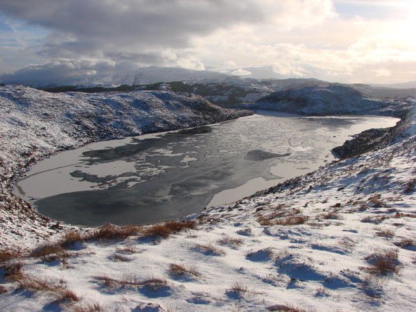
Ben More is a popular resort for hillwalkers all-year-round, yet its shoulder mountain, An Gearna, is rarely visited. In keeping with the Mull Magic pledge to try to celebrate the uncelebrated in 2011, we decided to deviate from the path up the side of the Dhiseig burn, in order to work our way to the cairn at the pinnacle of this ‘lesser’ mountain. We had the hill all to ourselves and enjoyed a truly wonderful few hours admiring the inaccessible (at least to walkers!) North face of Mull’s loftiest location, a view that would have been denied if we had chosen to scale the scree slopes of Ben More.

Although the sun refused to come out from behind the day’s veil of grey, the panorama North and West across Loch na Keal was quite brilliant. Stretching out as far as the eye could see beyond the dark, brooding cliffs of Gribun (1,800 ft) and the Isle of Ulva, we marvelled at the myriad of islands that presented themselves. The island of Staffa lay adrift of the Treshnish archipelago, with the outermost of the Inner Hebrides, Coll and Tiree, tucked behind, while on the grey horizon, sprinkled with the occasional rain shower, the Long Island spread out from Barra to North Uist. From our vantage point on the top of the world, it seemed that we really were looking out towards the very edge of creation!

Our eye’s journey North was equally impressive and dominated by the flat-topped Speinne Mor (1,456 ft), the V-shaped clefts of the Rum Cuillin and the snow-covered peaks of Skye in the distance. The foreground scene of Loch na Keal was governed by the sheep island of Eorsa, the setting for Nigel Tranter’s 1952 comic novel, ‘The Bridal Path’, which was later made into a film starring Bill Travers. In it, Travers plays a character on the look-out for a wife, a journey that, inevitably, takes him away from his island home. Equally inevitably, having failed in his search of the mainland, he finds love on his doorstep when he returns home.

Eorsa, uninhabited save for a local landowner’s sheep, was chosen for this very fact, as the story of book and film was about the dangers of in-breeding within a small community. The author wisely chose an unpopulated location in order not to offend, as well it may have done!